Last year, Stonex had the opportunity to contribute to data collection efforts for monitoring the Belvedere Glacier in Piedmont, Italy.
The XFLY drone-mounted LiDAR was used, enabling the creation of a detailed point cloud in a short amount of time. These data were integrated with other information already in possession of the Politecnico di Milano, obtained through continuous monitoring of the glacier.
The Geodetic and Photogrammetric Measurement Laboratory (LabMGF) of the Department of Civil and Environmental Engineering at the Politecnico di Milano, coordinated by Professor Livio Pinto, has been dedicated to monitoring the Belvedere Glacier since 2015.
This is a debris-covered alpine glacier (a so-called “black glacier”) located in Valle Anzasca, in the province of Verbano Cusio Ossola, at the foot of the eastern face of Monte Rosa. The glacier covers an area of about 1.8 km² and extends from 2250 meters above sea level down to 1800 meters, where it splits into two terminal lobes.
Monitoring by the Politecnico di Milano primarily relies on photogrammetric reconstruction techniques to generate 3D models of the glacier surface.
Since 2015, drone surveys have been carried out every spring-summer season. Each survey results in a point cloud that can be compared with previous models to visualize displacements and volume changes. In addition to drone flights, the geometry of the glacier was reconstructed for the years 1977, 1991, 2001, and 2009 using historical imagery from past photogrammetric flights. Since 2021, a pair of remotely operated cameras has been used to daily monitor the retreat of the northwest terminal lobe of the glacier.
The glacier’s morphology has been changing drastically since 2001, marking the beginning of a retreat phase characterized by significant ice volume loss, glacier tongue retraction, and thickness reduction. From 2015 to the present, an average loss of around 3 million cubic meters of ice per year has been measured, along with an average retreat of the terminal lobe of about 20 meters per year and an average thickness reduction of about 2 meters per year. Measurements from the last three years show an even faster rate of glacier retreat. For more information, refer to the project website: https://labmgf.dica.polimi.it/projects/belvedere/.
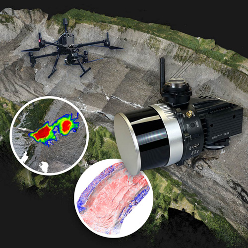
Stonex contributed to the creation of a 3D model on August 30, 2023, near the front of the glacier’s northwest lobe, where a large debris flow had recently occurred. The survey was conducted using the new XFLY drone-mounted LiDAR, and the flight took 30 minutes to cover the area of interest. Office processing with FLYpost software, compared to photogrammetry, is significantly faster and includes kinematic trajectory processing, from which the point cloud is reconstructed and subsequently colorized.
The LiDAR point cloud was used to calculate the volume of material deposited by the debris flow by comparing it with a photogrammetric point cloud obtained from a drone flight by the Politecnico di Milano on July 28, 2023 (before the event).
The comparison revealed an accumulation volume of approximately 206,000 cubic meters.
The LiDAR data obtained with the Stonex XFLY was thus added to the glacier’s data archive and compared with previous photogrammetric surveys.